Scotland
 UK
UK Ireland
 London

Scantech International Ltd
Telephone
Click to view
Fax
01625 260446
Website
Contact
Mr Keith McCrory
Address
2 Murrayfield
Macclesfield
Cheshire
North East
SK10 4BZ
England UK
About Scantech International Ltd
Specialist in 3D Laser Scanning, BIM & Much More
We have been providing 3D laser scanning services across a range of industry sectors since 2002, we were infact one of the first companies in the UK to purchase a 3D laser scanner. Making us one of the most experienced companies on the market
Scantech has gained a breadth of experience in providing solutions and adding value to a multitude of projects with many and varied clients.
Over the coming weeks we will be adding more project specific information and case studies to keep you informed of latest developments within Scantech and the ever changing world of 3D Laser Scanning technology.
BIM Modelling
BIM is centred around an intelligent multi-discipline 3-D CAD platform and is becoming increasingly adopted worldwide where it adds value to deliver:
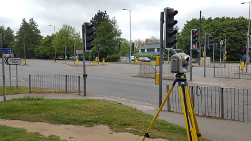
Topographical Surveys
If our client does not have a detailed specification we can provide a Topographic Survey template and we encourage our client’s involvement in the further definition of the survey specification. This may be simply a check-list approach to the level of survey detail or a more detailed specification such as in the RICS Specification Guidelines standard.
Setting Out Surveys
Setting out surveys provide constructors with accurate staked out positions related to the design drawings. We can load the design coordinates of buildings, foundations, steelwork and M&E etc into the EDM and identify and accurately mark these on site. This allows the constructors or builders to construct the features in accordance with the actual design requirements.
We have undertaken many such surveys and can provide a very competitive service in this area especially in the North West but also throughout the UK.
Measured Building Surveys
Measured building surveys is an accurate, 3D model of a building, which clearly shows all the relevant features and dimensions as they were at the time of the survey i.e. as-is or as-built. It is the result of a number of on-site measurements, the product of which can be provided in either 2D or 3D formats in the form of 2D drawings or a 3D model. Depending upon the client’s requirements, this deliverable would frequently include a combination of 3D model, floor and ceiling plans, sections and elevations.
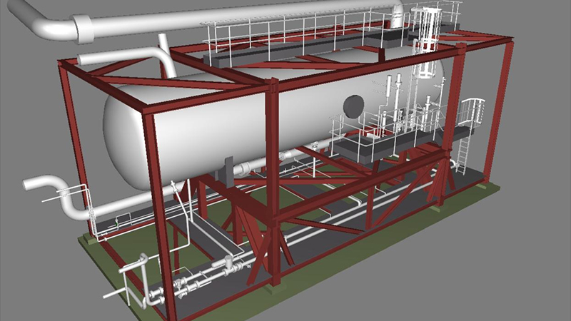
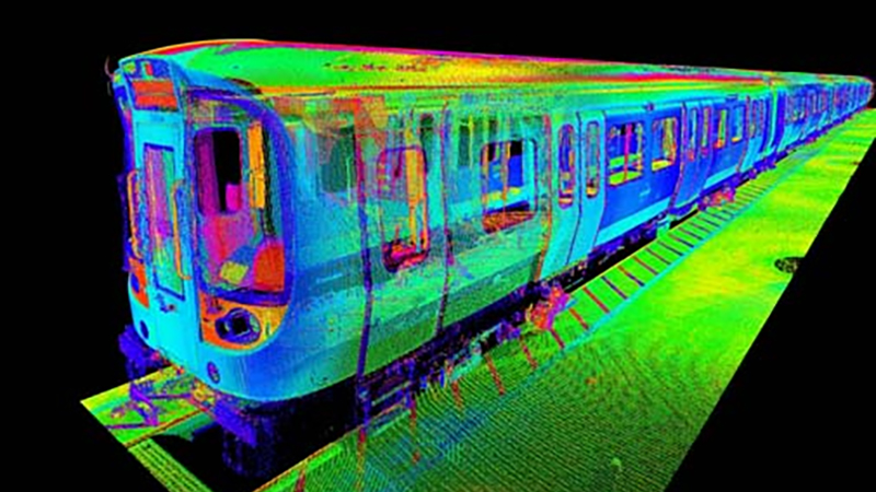
Asset Management and 3D Laser Scanning
Major developments in 3D laser Scanning technology and associated applications have meant that point cloud data is no longer restricted to use as a basis of design or as an as-built record. It is now possible to utilise the resulting data for asset management and project collaboration utilising innovative on-line tools.
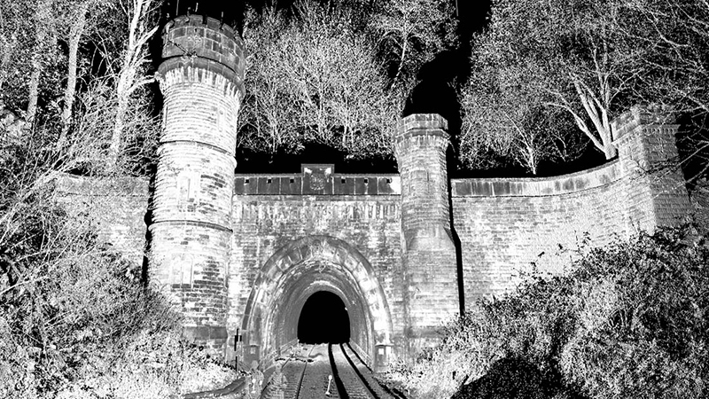
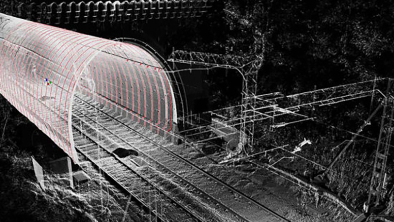
Elevation Survey
Over the last 15 years we have carried out dozens of Elevation Surveys using laser scanning including:
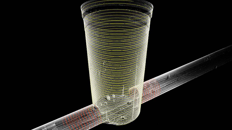
Site control is established by utilising either existing control stations or by installing new stations and coordinating these with our latest EDMs. Additional temporary control points are installed to assist in the registration of the individual scan data from each setup.
The registered pointcloud (both black and white or colourised) can also be imported by ourselves into LFM for use in PDMS.
With our engineering backgrounds we are uniquely placed to provide accurate as-built models for this type of infrastructure.
We have been providing 3D laser scanning services across a range of industry sectors since 2002, we were infact one of the first companies in the UK to purchase a 3D laser scanner. Making us one of the most experienced companies on the market
Scantech has gained a breadth of experience in providing solutions and adding value to a multitude of projects with many and varied clients.
Over the coming weeks we will be adding more project specific information and case studies to keep you informed of latest developments within Scantech and the ever changing world of 3D Laser Scanning technology.
BIM Modelling
BIM is centred around an intelligent multi-discipline 3-D CAD platform and is becoming increasingly adopted worldwide where it adds value to deliver:
- Optimum design
- Clash detection
- Constructability
- Operability and most importantly
- Reduced CAPEX and OPEX costs
Topographical Surveys
If our client does not have a detailed specification we can provide a Topographic Survey template and we encourage our client’s involvement in the further definition of the survey specification. This may be simply a check-list approach to the level of survey detail or a more detailed specification such as in the RICS Specification Guidelines standard.
Setting Out Surveys
Setting out surveys provide constructors with accurate staked out positions related to the design drawings. We can load the design coordinates of buildings, foundations, steelwork and M&E etc into the EDM and identify and accurately mark these on site. This allows the constructors or builders to construct the features in accordance with the actual design requirements.
We have undertaken many such surveys and can provide a very competitive service in this area especially in the North West but also throughout the UK.
Measured Building Surveys
Measured building surveys is an accurate, 3D model of a building, which clearly shows all the relevant features and dimensions as they were at the time of the survey i.e. as-is or as-built. It is the result of a number of on-site measurements, the product of which can be provided in either 2D or 3D formats in the form of 2D drawings or a 3D model. Depending upon the client’s requirements, this deliverable would frequently include a combination of 3D model, floor and ceiling plans, sections and elevations.
Asset Management and 3D Laser Scanning
Major developments in 3D laser Scanning technology and associated applications have meant that point cloud data is no longer restricted to use as a basis of design or as an as-built record. It is now possible to utilise the resulting data for asset management and project collaboration utilising innovative on-line tools.
Elevation Survey
Over the last 15 years we have carried out dozens of Elevation Surveys using laser scanning including:
- Buildings
- Viaducts
- Bridges
- Tunnel Portals
- Walls
- Embankments
- Cliffs
- Quarries
Site control is established by utilising either existing control stations or by installing new stations and coordinating these with our latest EDMs. Additional temporary control points are installed to assist in the registration of the individual scan data from each setup.
The registered pointcloud (both black and white or colourised) can also be imported by ourselves into LFM for use in PDMS.
With our engineering backgrounds we are uniquely placed to provide accurate as-built models for this type of infrastructure.
Gallery
Products & Services
Location Map
Scantech International Ltd Serves The Following Areas
Scantech International Ltd Serves The Following Council Areas